- Home
- Places to Stay
- Cities
- Northern Ireland
- Ireland
- Places to See
- Northern Ireland
- Northern Ireland by Region
- Ireland
- Ireland by Region
- Places to Eat & Drink
- Cities
- Northern Ireland
- Ireland
- Editor’s Picks
- Blog & News
- Feature YOUR Business Here
360° Aerial Photograph above East Belfast
Interactive Panoramic Aerial Photography, Northern Ireland
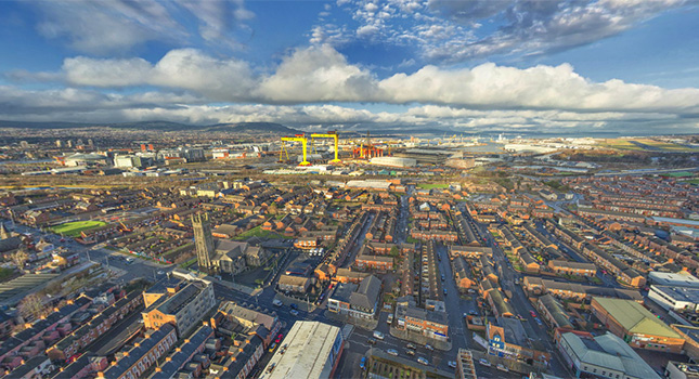
Check out this Aerial 360° Photograph captured above East Belfast.
In the distance you can see Belfast’s famous Harland & Wolff shipyard with their striking yellow gantry cranes. Within the 360° aerial photograph there are areas identified by clickable hotspots.
Click the marker points to be taken to the ground and into some of the famous landmarks across Belfast and beyond, places like The Thompson Dock at Titanic’s Dock & Pump-House – once the beating heart of Harland & Wolffs operation during the construction of the great White Star Liners – Britannic, Olympic and most famously the RMS Titanic.
Zoom up to McArt’s Fort on top of Cavehill. It is one of the most celebrated landmarks in the Hills of Belfast. This fort, on the summit of the hill, is an example of an old ráth or ring fort. It is protected on one side by a precipice. It is believed that the fort’s inhabitants used the caves to store white foods for the winter and may have served as a refuge during times of attack.
Some 20km further to the East you will see Scrabo Tower, easily one of Northern Ireland’s most recognisable landmarks, situated at the head of Strangford Lough, overlooking the old Market Town of Newtownards.
Our professional aerial photography camera rigs can offer a perspective that will amaze and captivate without the expense of a full size helicopter.
Address: Belfast, Northern Ireland


![City of Derry [ Video ]](https://www.virtualvisittours.com/wp-content/uploads/2013/04/Derry-Londonderry-150x150.jpg)

New


Popular


Comments
David Mcvea: Copeland Island Bird Observatory
Mike Gardiner: Mullylusty Cottage
Niall Mc Auliffe: Portlaw Heritage Centre
Hugh Heron: Mullylusty Cottage
John Smith: Irish National Heritage Park
Editors Picks

Antrim Town
Antrim is the county town of County Antrim in Northern Ireland. Antrim is a small town not frequently visited by tourists, yet it is one of the more historic towns in Northern Ireland with many interesting sights and buildings of historic note.
Connect with us


![]() Helped by Giant
Helped by Giant